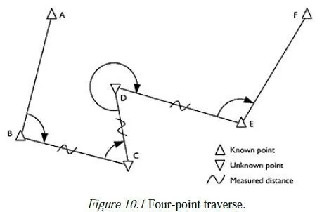
Before studying the art of levelling, it is necessary to clearly understand the following terms used in levelling:
1. Level Surface: A surface parallel to the mean spheroid of the earth is called a level surface and the line drawn on the level surface is known as a level line. Hence all points lying on a level surface are equidistant from the centre of the earth. Figure 15.1 shows a typical level surface.

2. Horizontal Surface: A surface tangential to level surface at a given point is called horizontal surface at that point. Hence a horizontal line is at right angles to the plumb line at that point [Ref. Fig. 15.2].

3. Vertical Line: A vertical line at a point is the line connecting the point to the centre of the earth. It is the plumb line at that point. Vertical and horizontal lines at a point are at right angles to each other [Fig. 15.2].
4. Datum: The level of a point or the surface with respect to which levels of other points or planes are calculated, is called a datum or datum surface.
5. Mean Sea Level (MSL): MSL is the average height of the sea for all stages of the tides. At any particular place MSL is established by finding the mean sea level (free of tides) after averaging tide heights over a long period of at least 19 years. In India MSL used is that established at Karachi, presently, in Pakistan. In all important surveys this is used as datum.
6. Reduced Levels (RL): The level of a point taken as height above the datum surface is known as RL of that point.
7. Benchmarks: A benchmark is a relatively permanent reference point, the elevation of which is known (assumed or known w.r.t. MSL). It is used as a starting point for levelling or as a point upon which to close for a check. The following are the different types of benchmarks used in surveying:
(a) GTS benchmarks (b) Permanent benchmarks
(c) Arbitrary benchmarks and (d) Temporary benchmarks.
(a) GTS Benchmark: The long form of GTS benchmark is Great Trigonometrical Survey benchmark. These benchmarks are established by national agency. In India, the department of Survey of India is entrusted with such works. GTS benchmarks are established all over the country with highest precision survey, the datum being mean sea level. A bronze plate provided on the top of a concrete pedastal with elevation engraved on it serves as benchmark. It is well protected with masonry structure built around it so that its position is not disturbed by animals or by any unauthorised person. The position of GTS
benchmarks are shown in the topo sheets published.
(b) Permanent Benchmark: These are the benchmarks established by state government agencies like PWD. They are established with reference to GTS benchmarks. They are usually on the corner of plinth of public buildings.
(c) Arbitrary Benchmark: In many engineering projects the difference in elevations of neighbouring points is more important than their reduced level with respect to mean sea level. In such cases a relatively permanent point, like plinth of a building or corner of a culvert, are taken as benchmarks, their level assumed arbitrarily such as 100.0 m, 300.0 m, etc.
(d) Temporary Benchmark: This type of benchmark is established at the end of the days work, so that the next day work may be continued from that point. Such point should be on a permanent object so that next day it is easily identified.
what real actual R.L at m.s.l Karachi.