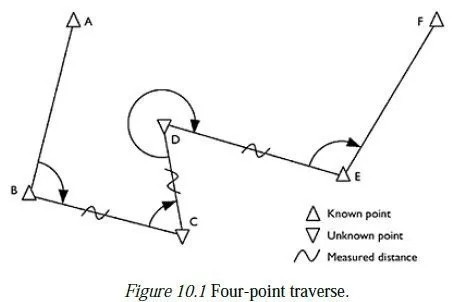
The following are the different types of direct levelling:
(i) Simple levelling (ii) Differential levelling
(iii) Fly levelling (iv) Profile levelling
(v) Cross sectioning and (vi) Reciprocal levelling.
Simple Levelling
It is the method used for finding difference between the levels of two nearby points. Figure 15.6 shows one such case in which level of A is assumed, say 200.00 m. RL of B is required.

RL of A = 200.00 m
Back sight on A = 2.7 m.
∴ Plane of collimation for setting at station = 200 + 2.7 = 202.7 m
Fore sight on B = 0.80 m
∴ RL of B = 202.7 0.80 = 201.9 m
It may be noted that the instrument station L1 need not be along the line AB (in plan) and RL of L1 do not appear in the calculations.
Differential Levelling
If the distance between two points A and B is large, it may not be possible to take the readings on A and B from a single setting.
In such situation differential levelling is used. In differential levelling the instrument is set at more than one position, each shifting facilitated by a change point. Figure 15.7 shows a scheme of such setting.

RL of A is 200.00 m. Instrument is set up at L1 and back sight on A is 1.35 m. The fore sight on
change point CP1 is 1.65 m. Then instrument is shifted to L2 and back sight on CP1 is 1.40 m. Fore sight
on CP2 is 1.70 m. After this instrument is shifted to L3 and back sight on CP2 is 1.3 m. The work ended
with a fore sight of 1.85 m on B. The RL of B is to be found.
RL of A = 200.00 m
Back sight on A = 1.35 m
∴ Plane of collimation at L1 = 200 + 1.35 = 201.35 m
Fore sight on CP1 = 1.65 m
∴ RL of CP1 = 201.35 1.65 = 199.70 m
Back sight to CP1 from L2 = 1.40
∴ Plane of collimation at L2 = 199.70 + 1.40 = 201.10 m
Fore sight to CP2 = 1.70 m
∴ RL of CP2 = 201.10 1.70 = 199.40 m
Back sight to CP2 from L3 = 1.30 m
∴ Plane of collimation at L3 = 199.40 + 1.30 = 200.70 m
Fore sight to B = 1.85 m
∴ RL of B = 200.70 1.85 = 198.85 m Ans.
If there are intermediate sight to the points E1 and E2, the RL of those points may be obtained by subtracting readings for E1 and E2 from the corresponding plane of collimations.
Booking and Reducing the Levels
The booking of readings and reducing the levels can be carried out systematically in the tabular form.
There are two such methods:
(i) Plane of collimation method (ii) Rise and fall method.
For the above problem, with intermediate sights to E1 = 0.80 m and E2 = 0.70 m is illustrated below by the both methods.

In this method note the following:
1. Plane of collimation for first setting
= RL of BM + BS
2. Subtract IS from plane of collimation to get RL of intermediate station and subtract FS from plane of collimation to get RL of change point.
3. Add back sight to RL of change point to get new plane of collimation.
4. Check: Σ BS Σ FS = RL of Last point RL of first point.
If it is ve, it is fall and if +ve it is rise.

Note the following:
1. From A to E1, difference = 1.35 0.80 = 0.55, rise
2. From E1 to CP1, difference = 0.80 1.65 = 0.85, fall
3. From CP1 to E2, difference = 1.40 0.70 = 0.70, rise
4. From E2 to CP2, difference = 0.70 1.70 = 1.00, fall
5. From CP2 to B, difference = 1.30 1.85 = 0.55, fall.
Fly Levelling
If the work site is away from the benchmark, surveyor starts the work with a back sight on the benchmark by setting instrument at a convenient point. Then he proceeds towards the site by taking fore sights and back sights on a number of change points till he establishes a temporary benchmark in the site. Rest of the levelling work is carried out in the site. At the end of the work again levelling is carried out by taking a set of convenient change points till the bench work is reached. This type of levelling in which only back sight and fore sights are taken, is called fly levelling, the purpose being to connect a benchmark with a temporary benchmark or vice versa. Thus the difference between fly levelling and differential levelling is only in the purpose of levelling.
Profile Levelling
This type of levelling is known as longitudinal sectioning. In high way, railway, canal or sewage line projects profile of the ground along selected routes are required. In such cases, along the route, at regular interval readings are taken and RL of various points are found. Then the section of the route is drawn to get the profile. Figure 15.8 (a) shows the plan view of the scheme of levelling and Fig. 15.8 (b)
shows the profile of the route. For drawing profile of the route, vertical scale is usually larger compared to scale for horizontal distances. It gives clear picture of the profile of the route.

The typical page of field book for this work will be having an additional column to note distances as shown in Table 15.3.

Cross-Sectioning
In many engineering projects, not only longitudinal profile but also the profile of cross-sections at regular intervals are required. These profiles help in calculating the earth works involved in the projects.
Figure 15.9 shows the scheme of such work in which longitudinal profile is found by taking readings at 20 m interval along chain lines AB, BC and readings are taken at an interval of 3 m on either side. The distances on the cross-sections are treated as left or right of the lines as they are found while facing the forward station of survey. The cross-sectional length depends upon the nature of the project.

Reciprocal Levelling
In levelling, it is better to keep distance of back sight and fore sight equal. By doing so the following errors are eliminated:
(i) Error due to non-parallelism of line of collimation and axis of bubble tube.
(ii) Errors due to curvature and refraction.
But in levelling across obstacles like river and ravine, it is not possible to maintain equal distances for fore sight and back sight. In such situations reciprocal levelling as described below is used:
Hi i like your note
good notes