
Electromagnetic Distance Measuring Instruments
Sun light or artificially generated electromagnetic waves consists of waves of different lengths. The spectrum of an electromagnetic wave is as […]
Surveying is the art of making measurements of objects on, above or beneath the ground to show their relative positions on paper. The relative position required is either horizontal, or vertical, or both. Less precisely the term Surveying is used to the measurement of objects in their horizontal positions. Measurements to deteremine their relative vertical positions is known as levelling.
Sun light or artificially generated electromagnetic waves consists of waves of different lengths. The spectrum of an electromagnetic wave is as […]

5.1 General Distances may be measured by four methods: direct, optical, electromagnetic or GPS. The method used for any particular

The magnetic meridian and the true meridian may not coincide with each other in a place. The horizontal angle between these
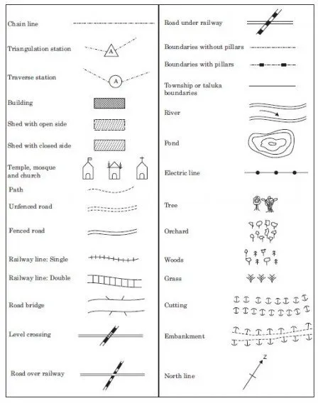
IS 962 1989, code of practice for architectural and building drawings has specified standard symbols for various objects as shown

A contour line is a imaginary line which connects points of equal elevation. Such lines are drawn on the plan of

If the area is bound by straight edges, it can be subdivided in a set of convenient figures and area calculated.

If map of an area is available its area can be found by the following methods: (i) Approximate methods (ii)

The following three methods are available for computation of volumes: (i) From cross-sections (ii) From spot levels and (iii) From
At any point, if bearings of any two lines are known, the angle between these two lines can be easily found

Surveying may be classified on the following basis: (i) Nature of the survey field (ii) Object of survey (iii) Instruments