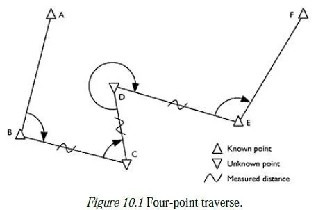
D.1 Quick calculation
The quick formula for calculating a scale factor is:
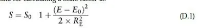
where S0 is the central scale factor, E0 the false easting of the true origin and RE the mean radius of the earth.
This formula is accurate to 2 parts per million at all places within 200 km of the central meridian, and to 50 parts per million up to 500 km. At the latitude of Great Britain the accuracy is better still, as shown in the example below.
D.2 Precise calculation
This calculation is a simplified (but no less accurate) adaptation of the formulae given in Ordnance Survey (1950). As far as possible, the same symbols have been used here, to enable comparison between the two approaches.
The data needed to start the calculation are as follows:
â— the semi-major axis (a) and some other property (semi-minor axis, reciprocal of
flattening or eccentricity) of the ellipsoid;
â— the central scale factor (F0) and the false easting of the true origin (E0);
â— the exact easting (E) and approximate northing (N) of P, the point where the local scale factor is to be calculated.
1 The first step is to calculate e2, the square of the eccentricity of the ellipsoid. If this is not directly available, it can be calculated from:
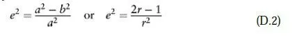
where b is the semi-minor axis of the ellipsoid and r the reciprocal of flattening.
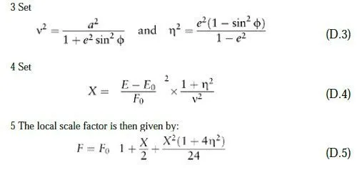
2 Use E and N to estimate Φ, the latitude of P. This needs to be estimated to the nearest 0.2° to achieve an accuracy of eight significant figures even an error of 5° will only affect the final answer by less than 1 part per million.
Strictly the value which should be used in the calculations below is Φ², the latitude of the point on the central median with the same northing as P. However, the difference between Φ and Φ² is never more than 0.1°, provided the difference in the longitudes of the two points is less than 4° so the distinction has little practical significance.
D.3 Example
Local scale factor at Framingham, UK, on the British National Grid Framingham is a first-order control point in the British National Grid, towards the eastern edge of the projection. This example has been used because it is also used as an example in Ordnance Survey (1950). Its co-ordinates are quoted as 626,238.249E, 302,646.415N. Precise calculation
From Appendix A:
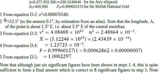
also that the final term in expression D.4 need only be included if eight or more significant figures are required.
Quick calculation
Applying the quick formula to the same example gives:
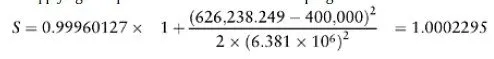
This differs from the accurate value by just 0.2 parts per million.