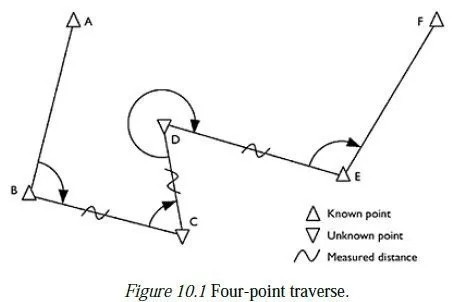
Control stations
B.1 What is a control station?
The essence of a control station is a small mark set immovably into the ground, such that an instrument (e.g. a total station or GPS receiver) or optical target can be set up above it, to an accuracy of about 1 mm in the horizontal plane.
B.2 Where are they placed?
Control stations are not usually placed in an exactly predetermined position. The normal process is to choose a location where a control station would be useful, and to place the station somewhere in that locality. Having built the station, precise measurements are then taken to determine exactly where it has in fact been placed. The factors which influence the positioning of a control station are as follows: 1 If it is to be used for setting out, or for deformation monitoring, then it should be placed where all relevant places and features can be easily seen, without the line of sight passing close to another object such as a building or hillside (a grazing ray). If the station is to be used in conjunction with other similar stations for these purposes (as is usually the case) then the different lines of sight from the stations should form a wellconditioned shape, so that the positions of the observed points will be found to the greatest possible accuracy.
2 If the exact position of a new control station is to be fixed by conventional means, then it must be visible from at least two other control stations (and preferably from more). Sometimes, additional control stations are introduced into a network simply because they will be visible to several useful stations and will therefore improve the accuracy to which the positions of those stations are known.
3 If the station is to be used for GPS, then a large area of sky should be visible at the station (particularly towards the equator), and there should not be any high walls nearby which might reflect satellite signals towards the receiver.
4 If an instrument is to be left unattended at a station (e.g. a motorised total station or a reference GPS receiver), then the station must be in a secure place, such that the instrument cannot be stolen or disturbed while the surveyor is elsewhere.
5 As far as possible, a station should be sited in a place where it will be easy and safe to use (away from noise, vibration, traffic, etc.) and unlikely to be disturbed or destroyed during its anticipated useful life. Stations sited near roads or on tarmac pathways are always at risk of being covered over, and lost without trace. Stations in the middle of building sites are at risk of being dug up, or run over by heavy construction traffic.
The latter may not destroy a station, but it could move it slightly and thus cause all subsequent observations involving the station to be subtly inconsistent with those made beforehand.
B.3 What do control stations look like?
The physical appearance of a control station depends mainly on the place where it is sited and its anticipated useful lifespan. In open ground, a shortterm control station might be a 1 mm diameter hole or centre pop in a brass tack driven into a short (30 cm) wooden stake, which is then hammered into the ground; on tarmac, it might be a centre mark on a stainless steel road bolt, which is likewise driven into the ground. Such road bolts normally have a hemispherical head with a diameter of about 5 mm, on top of a fixed disk about 20 mm in diameter. They may also have a coloured plastic washer, or a circle painted round them, for identification purposes. For a more permanent marker in open ground, a precast reinforced concrete block with a suitable marker on its surface might be dug into the ground, so that only its top surface is visible. Alternatively, a hole can be dug with some ferrous reinforcing bars arranged inside it and a quantity of concrete poured in, with a non-rusting marker fixed so as to emerge slightly above the surface of the concrete when it has set; a small solid brass doorknob, some threaded steel rod which it will screw onto and some ready-mix concrete for fence posts is all that is required. This gives an extremely durable station at very modest cost, which has the added advantage that it can be covered over with a piece of turf or layer of soil, and thus escape the risk of being vandalised when not in use. If the upper surface of the marker is spherical, then its highest point can also conveniently be taken to be the height of the station. A control point on a construction site would normally be surrounded by a small rectangular fence, made of brightly painted wood, to warn drivers of its existence. This reduces the likelihood of the station being run over by a heavy vehicle, and a broken fence gives a helpful indication that this may have happened. In Britain there are still many Trig Pillars to be found on hilltops, which formed part of the conventional control network used until the advent of GPS. These are intricately designed monuments and act as a housing for the actual station marker, which is near ground level inside the pillar (the height marker is a separate benchmark on the side of the pillar). In addition, there is a secondary station marker in a buried chamber directly beneath the main marker, so that the station could be recovered if the pillar was destroyed. Such pillars are highly durable, but nonetheless need regular inspection to detect and repair the damage, both accidental and deliberate, which they sometimes suffer. Some of these Trig Pillars are nonetheless still maintained and form part of the newer network of GPS stations around the UK. However, most GPS control stations are markers set in concrete slightly below ground level, as described above.
B.4 How can they be found?
As implied above, the less obtrusive a control station is, the less likely it is to suffer damage. Recently constructed stations can therefore be virtually impossible to find, unless you know exactly where to look. When a new station is constructed, an essential part of the process is to draw a small sketch map of the area, showing clearly where the station is in relation to other visible and recognisable features nearby. At least three measurements should be taken from the station to definite measurable reference points such as a tree, the corner of a manhole cover, a nail driven into the top of a particular fencepost or the perpendicular distance to the edge of a nearby road. These should be taken with a tape measure, corrected at least to the nearest 5 cm and should be arranged such that the station could still be found even if it was well buried and one of the reference points had subsequently disappeared. It is useful to show the approximate direction of magnetic north on the sketch, too. To find a buried station, a surveyor should ideally be equipped with a paper copy of the sketch map described above, the co-ordinates of the station (GPS or Grid), a handheld GPS receiver, two 30-m tape measures, a metal detector and a spade. The hand-held receiver and the station co-ordinates will narrow the search to about 10 m, such that the features on the sketch map are clearly recognisable. Measuring simultaneously from two of the reference points should then indicate where to dig, and the metal detector can be used in cases of doubt (assuming the concrete contains some ferrous metal, as recommended above).